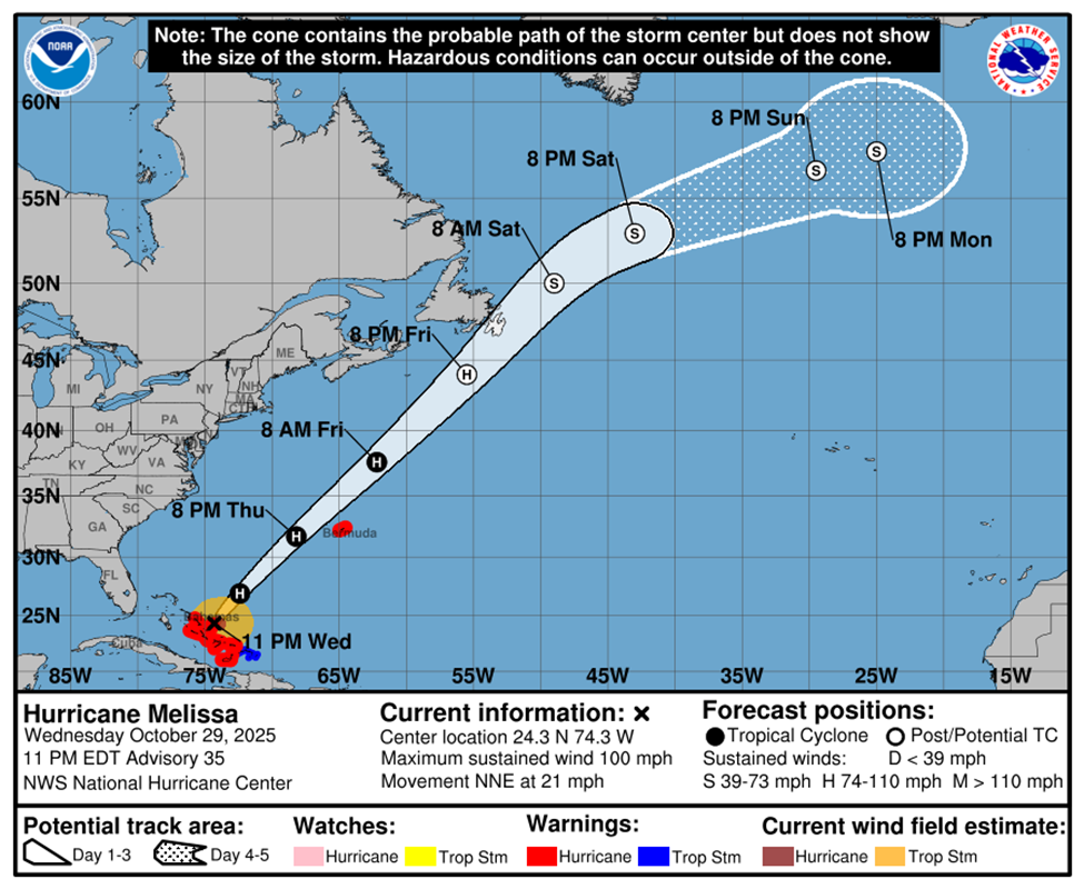
Alert #28 on Hurricane Melissa issued by The Bahamas Department of Meteorology at 3AM, Thursday October 30th, 2025.
…HEAVY RAINS AND GUSTY WINDS CONTINUE OVER PORTIONS OF THE CENTRAL AND SOUTHEAST BAHAMAS…
… TROPICAL STORM AND HURRICANE CONDITIONS ARE STILL OCCURRING IN PARTS OF THE CENTRAL AND SOUTHEAST BAHAMAS AND IS EXPECTED TO SUBSIDE BY SUNRISE…
A Hurricane Warning remains in effect for the Central and Southeast Bahamas. This includes Exuma and its Cays, Ragged Island, Rum Cay, Long Island, San Salvador, Cat Island, Acklins, Crooked Island, Long Cay, Mayaguana, and Inagua.
A Hurricane Warning means that Hurricane conditions are expected in the mentioned islands within 36 hours.
A Tropical Storm Warning is in effect for the Turks and Caicos Islands.
A Tropical Storm Warning means that Tropical Storm conditions are expected in the mentioned islands within 36 hours.
At 2 AM EDT, the center of Hurricane Melissa was located near Latitude 24.8 degrees North and Longitude 73.9 degrees West, or about, 65 miles Northeast of Cockburn Town, San Salvador, 100 miles Northeast of Port Nelson, Rum Cay, 145 miles Northeast of South Long Island, 105 miles East-northeast of New Bight Cat Island and 210 miles East of New Providence.
Hurricane Melissa is moving toward the North-northeast near 21 miles per hour and the hurricane is expected to continue accelerating northeastward during the next few days. On the forecast track, the core of Melissa is expected to move away from the Southeast and Central Bahamas this morning then pass near or to the West of Bermuda later today and tonight.
Maximum sustained winds are near 100 miles per hour with higher gusts. Further strengthening is possible on today before weakening likely begins on Friday Hurricane-force winds extend outward up to 60 miles from the center, and tropical-storm-force winds extend outward up to 185 miles.
Tropical Storm and hurricane conditions continue to occur in the parts of Central and Southeast Bahamas. These conditions will subside by sunrise today.
Residents should remain indoors until the winds subside.
Impacts:
Hurricane Melissa brought extended periods of violent winds, heavy rain, and widespread inland and coastal flooding, along with hazardous sea conditions, to the islands in the Central and Southeast Bahamas, as well as the Turks and Caicos Islands. The islands receiving the strongest impact are Ragged Island, Long Island, Acklins, Crooked Island, Long Cay, Samana Cay, Rum Cay, and San Salvador. However, the extent of the impact depends on Melissa's strength as it moves through the Central and Southeast Bahamas.
Rainfall Amount:
A total rainfall of 5 to 10 inches is expected over the Southeast Bahamas through this morning, resulting in severe flooding in the islands. Expected rainfall totals for the Turks and Caicos Islands are approximately 1 to 3 inches.
Storm Surge:
A storm surge of 4 to 7 feet above normally dry ground is possible in the Southeast Bahamas, and minor coastal flooding is possible in the Turks and Caicos Islands today.
The next Alert on Hurricane Melissa will be issued at 6 AM.
Issued by: Gregory D Thompson (CCO)
Duty Forecaster


