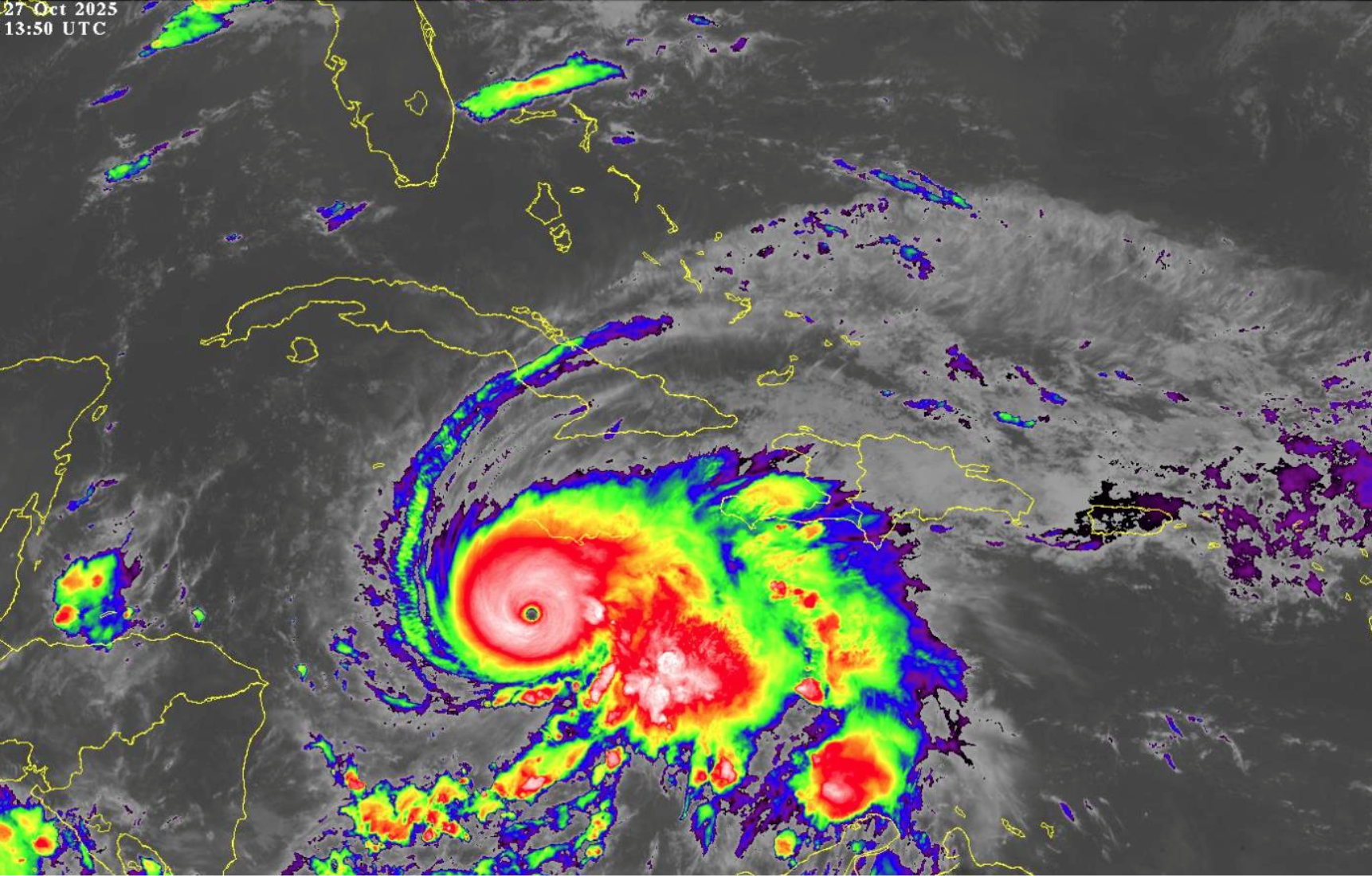
ALERT #8 ON HURRICANE MELISSA issued by The Bahamas Department of Meteorology, Monday, October 27th, 2025, at 3 PM EDT.
…CATEGORY 5 HURRICANE MELISSA MOVING SLOWLY WEST- NORTHWESTWARD AND EXPECTED TO TURN NORTHWARD LATER TODAY …
…TROPICAL STORM AND HURRICANE CONDITIONS EXPECTED IN THE ISLANDS OF THE SOUTHEAST BAHAMAS, INCLUDING THE TURKS AND CAICOS, BEGINNING ON TUESDAY, AND THE CENTRAL BAHAMAS ON WEDNESDAY THROUGH THURSDAY…
A Hurricane Watch is now in effect for the Central and Southeast Bahamas and the Turks and Caicos Islands. This includes Exuma and its Cays, Ragged Island, Rum Cay, Long Island, San Salvador, Cat Island, Acklins, Crooked Island, Long Cay, Mayaguana, Inagua, and the Turks and Caicos Islands.
A Hurricane Watch means that Hurricane conditions could be experienced within the mentioned islands within 48 hours.
At 2 PM EDT, the center of Hurricane Melissa was located near latitude 16.5 degrees north and longitude 78.3 degrees west, or about 145 Southwest of Kingston, Jamaica, 440 miles South-southwest of Duncan Town, Ragged Island,
420 miles Southwest of Matthew Town, Inagua 510 miles Southwest of Providenciales, Turks and Caicos Islands, 520 miles Southwest of Abraham’s Bay, Mayaguana and 585 miles South of New Providence.
Hurricane Melissa is moving toward the west-northwest near 3 miles per hour. A slow turn toward the northwest and north is expected later today, followed by a turn toward the northeast and a faster forward speed on Tuesday. A northeastward motion is expected on Wednesday and Thursday. On the forecast track, the core of Melissa is expected to move over Jamaica tonight and early Tuesday, across Southeastern Cuba Tuesday night, and across the Southeast Bahamas on Wednesday.
Maximum sustained winds remain 175 miles per hour with higher gusts. Hurricane Melissa is a Category 5 hurricane on the Saffir-Simpson Hurricane Wind Scale. Some fluctuations in intensity are likely before Melissa makes landfall in Jamaica on Tuesday. However, Melissa is expected to reach Jamaica and southeastern Cuba as an extremely powerful major hurricane and will still be at hurricane strength when it moves across the southeast Bahamas and the Turks and Caicos Islands.
Hurricane-force winds extend outward up to 30 miles from the center, and tropical- storm-force winds extend outward up to 195 miles.
Residents in the Southeast Bahamas and the Turks and Caicos Islands should continue to make preparations for the possibility of Tropical Storm and Hurricane conditions beginning late Tuesday night or early Wednesday morning, and in the Central Bahamas on Wednesday through Thursday. Residents in the Northern and Northwest Bahamas should closely monitor Alerts issued by the Bahamas Department of Meteorology and be ready to prepare for possible Tropical Storm or Hurricane conditions in the next few days.
Potential Impacts:
Hurricane Melissa, should it continue to move along the forecast track, will bring prolonged periods of strong winds, heavy rainfall, and coastal inundation to the islands in the Central and Southeast Bahamas, as well as the Turks and Caicos Islands, beginning Tuesday through Thursday. However, the magnitude of potential impacts depends on the intensity of Melissa as it approaches The Bahamas.
Melissa is forecast to interact with major mountainous landmarks, such as those in Jamaica and Cuba or Hispaniola, which could potentially weaken the system slightly as it nears the Southeast and Central Bahamas late Tuesday and Wednesday.
Rainfall Amount:
A total rainfall amount of 4 to 8 inches is expected over the Southeast Bahamas and 4 to 6 inches over the Turks and Caicos from Tuesday into Wednesday, resulting in severe flooding.
The next Alert on Hurricane Melissa will be issued at 6 PM EDT.
Issued by: Mary Butler


